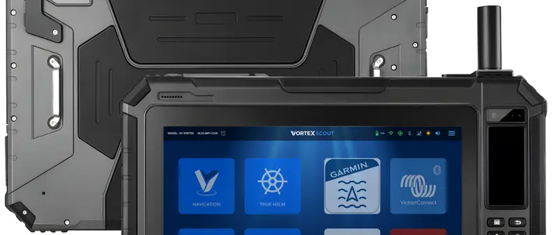
A navigator that moves from helm to tender
Vortex Marine has introduced Scout, a portable marine navigator designed to move between a yacht's helm, its cabins and a tender. Announced in mid-October 2026, the 10.1-inch device brings electronic nautical charts, satellite imagery, weather data and compatible onboard instruments onto a rugged screen. The New Zealand company is positioning Scout alongside established marine equipment rather than as a substitute for all the fixed displays already installed on a boat.
The idea is practical for cruising crews who currently switch among a chartplotter, a tablet and several specialist applications to plan a passage. Comparing the coastline on a chart with satellite photographs can provide another perspective on an unfamiliar approach. That convenience does not remove the need for reliable surveys, a depth sounder, visual observations or the judgement of the person navigating.
Charting and satellite imagery in one view
Scout runs VortexNav, which combines electronic charts and satellite mapping on a screen that allows users to blend the two views. A slider transitions from cartographic symbols and contours to an image of the landscape, providing a different way to examine reefs, shoals and shorelines. The company says this is useful in regions where older chart surveys may have less detail than modern navigators would prefer.
Satellite images have limitations of their own. Water colour, surface conditions, tide, cloud cover and the date of an image can affect what is visible. A patch of blue water in a photograph cannot establish safe depth for a particular vessel, and the position or shape of hazards can change. Mariners should treat the extra imagery as supporting information, never as a guarantee of navigability.
Ten-inch hardware made for the water
The manufacturer lists a 10.1-inch, 1920-by-1200 display with peak brightness of 1,000 nits to improve readability under strong sun. Scout uses an ARM-based processor with 8GB of RAM, 128GB of internal storage and a MicroSD slot for additional capacity. A 14,600mAh battery, physical controls and touch operation are included so the unit can function away from permanent power and fixed mounting points.
Vortex gives the tablet an IP65 rating against dust and water jets, with drop and vibration testing under MIL-STD-810G. Those characteristics make it more appropriate for spray and exposed deck use than a standard office tablet, although IP65 does not mean waterproof under prolonged submersion. A twelve-month warranty is specified. Buyers should establish suitable mounting, charging and protective arrangements for their own boat.
Weather layers can travel offshore
Scout can overlay forecasts on nautical charts or satellite views, using weather information associated with models such as GFS, ECMWF and WaveWatch III. Mariners can inspect animated wind patterns, study forecast changes and plan their departure around an expected weather window. Vortex says forecasts may also be saved on the device before leaving a connected area, subject to the selected service plan and the information downloaded.
That capability may reduce dependence on a live internet connection during a passage, but downloaded forecasts become older as time passes. A changing situation offshore still requires access to current warnings and an independent means of receiving updates. The application's visual presentation may help people interpret complex information, yet the underlying model remains a forecast rather than a promise about actual conditions.
Instruments through an onboard network
Scout can receive compatible NMEA 2000 information over Wi-Fi, including position, heading, speed, depth, wind and AIS data where the boat provides those signals. This allows a crew to view existing onboard information without installing a separate set of sensors for the tablet. Owners who already use an established plotter may add the portable screen as a complementary display.
The manufacturer's configuration page offers a Yacht Devices NMEA Wi-Fi gateway as an optional accessory, including a SeaTalk NG variant for compatible installations. Some boats will therefore require extra hardware or setup to connect their instruments. AIS depends on receiving a usable signal from the appropriate equipment, and the absence of an AIS target cannot prove that the surrounding water is clear of traffic.
Tidal planning and anchor monitoring
The system includes tools for predicting local tides, planning routes and monitoring a vessel at anchor. VortexTide calculates tidal curves using harmonic information, while the VortexAnchor application is intended to show an anchor swing circle and historical movement. These functions may be useful when deciding on an anchoring position or planning a departure around tidal constraints.
An electronic prediction cannot verify actual water depth without appropriate local data, and a GPS-based alarm does not confirm that an anchor has properly set. Chain length, seabed type, neighbouring vessels and changing conditions remain important. Some of the extended anchor and navigation capabilities are associated with Polaris+, so owners should establish the exact functions available with their selected subscription.
Core software and optional upgrades
Every Scout runs the company's Android-derived PolarisOS with basic navigation facilities available without a continuing subscription. Optional Polaris+ packages add higher satellite zoom levels, longer forecast downloads and certain enhanced AIS, tidal or anchoring functions. Offline imagery depends on the licensed data and rules for the chosen tier. The distinction is important for someone comparing the device with a traditional fixed chartplotter.
The current manufacturer's site lists the Scout starting at US$1,279 before selecting extra equipment or software. Import taxes, local currency, accessories and ongoing subscriptions may alter the actual cost to an owner. A buyer should compare the complete package, especially if deeper satellite imagery or more extensive offshore weather downloads are among the main reasons for choosing the product.
What prospective users should check next
Vortex plans to show Scout at METSTRADE in Amsterdam on 17–19 November 2026, giving marine professionals an opportunity to assess the device after its October introduction. The portable format, bright display and combination of charts, satellite images and boat data are its distinguishing features. The broader marine electronics market already offers many ways to obtain these functions, so integration and usability will be key comparisons.
Before purchasing, owners should examine chart coverage in the cruising area, how offline imagery is licensed, whether the boat's instruments can connect and where the unit can be mounted or charged. A rugged second screen may add useful flexibility and redundancy, but it is not a replacement for primary navigation or good seamanship. The manufacturer's detailed specifications provide a starting point for evaluating those requirements.