A November announcement with two distinct objectives
The Buffalo District of the United States Army Corps of Engineers announced on 5 November 2026 that dredging at Sandusky Harbour, Ohio, had been completed that day. Approximately 109,000 cubic yards of material were removed under a US$628,000 contract awarded in July to Morrish-Wallace Construction Co. The project addressed the federal navigation channel, including the Moseley and Straight Channels. The majority of the recovered material was deposited at a designated nearshore site, where natural currents are expected to distribute sediment along the Lake Erie coast.
The work is relevant to captains exploring the western lake because the condition of navigable water and the character of its adjacent shoreline can have a common physical cause. A dredging programme is intended to maintain an established channel; placement of recovered sediment is a separate decision involving the characteristics of the material and the receiving environment. The Corps' statement describes the completion of these particular operations, rather than a declaration that every recreational approach in Sandusky Bay is newly surveyed or guaranteed to accommodate a yacht.
Where the recovered material went
The agency gives a useful breakdown of the quantities involved. Of the approximate 109,000 cubic yards recovered during the operation, 100,000 were deposited at the selected nearshore location, while 9,000 were placed at a designated open-lake site. This distribution means approximately 92 percent of the reported volume went to the nearshore location. The approach therefore differs from a programme in which every load of dredged material is removed permanently from the immediate coastal system.
The Corps describes the intended benefit as nourishment of the local coast through redistribution by natural currents. This is not equivalent to constructing a new beach to a predetermined finished shape. The ultimate distribution of the sediment will depend on factors including its grain characteristics, the site's configuration and subsequent water movement. The November announcement does not provide monitoring results demonstrating the eventual amount of material retained on any individual stretch of shore.
For yacht owners who explore the Great Lakes, this is an opportunity to understand why the management of the shoreline and that of a navigation channel are often connected. Natural sediment transport can be desirable in one location and problematic in another.
The contrast with the previous year's programme
Sandusky Harbour was dredged in 2025, when the Corps reports approximately 9,000 cubic yards of material were removed and deposited at the open-lake site. The much larger volume in the 2026 programme is significant, but the two totals alone do not establish an equivalent change in the annual rate of sediment accumulation. Project scopes, the areas addressed, available funding and the timing of surveys can affect the work selected for an individual year.
The district says Sandusky Harbour is dredged annually according to shoaling conditions, funding and federal navigation priorities. This qualified description is important for a captain whose future itinerary includes the area. It does not establish a fixed annual sequence or guarantee that a particular channel will be maintained immediately before a chosen visit. Maintenance decisions depend on assessments of the infrastructure rather than the dates on which private visitors hope to arrive.
An owner can use historical announcements to learn something about the organisation responsible for a commercial approach, but should use current official information when deciding whether a specific route is suitable.
The relationship between the channel and the recreational waterfront
The federal navigation project supports a working harbour used by large commercial vessels. The agency identifies authorised depths between 21 and 26 feet, with differences between the Straight and Moseley Channels. These figures help describe the design and maintenance requirements of the federal project.
A crew should distinguish such authorised dimensions from the actual depth available at a particular position. Lake level, local shoaling, survey coverage and the date of the information all affect the assessment. This distinction remains important for privately operated yachts that draw substantially less than the authorised channel depth. The yacht may leave the maintained channel in order to reach its berth, and the route beyond that point could have quite different constraints.
The announcement covers dredging in the named federal channels. It does not describe the depths of individual yacht-club basins, private slips, ramps or recreational marinas. An owner arranging a visit should obtain information from the operator responsible for the specific facility and reconcile it with authoritative nautical information used by the captain.
Taking the dimensions of a substantial yacht seriously
A yacht of twelve to twenty-four metres occupies a particular position within the recreational fleet. Although substantially smaller than a commercial cargo vessel, it may have a beam, loaded displacement, windage or fixed keel that places it outside the normal requirements of a small visiting craft. Owners should supply the actual dimensions and characteristics of the vessel when asking about a berth rather than rely on a model designation or a nominal length.
The appropriate mooring arrangement must be capable of securing the yacht under the conditions for which it is intended. The available space for manoeuvring and the relationship between the berth and neighbouring vessels should also be considered. Electrical demand and shore access can influence the choice where the family intends to remain aboard for several nights.
These details are particularly important when making seasonal plans. A harbour whose commercial channel receives substantial public investment does not necessarily provide utility connections or visiting spaces designed for larger private yachts. The existence of dredging equipment in the area does not establish that work has extended to those facilities.
What nearshore sediment placement can and cannot establish
The scale of the nearshore placement gives the project interest beyond commercial navigation. A system in which suitable sediment can contribute to the coastal environment may allow the material to serve a purpose after removal. The responsible agencies must consider where it can be placed, how it will behave and the characteristics of the receiving environment.
The Corps' announcement identifies a beneficial intended use rather than presenting a complete environmental assessment or a post-placement survey. It should not be interpreted as proof that the deposited material has already produced a specified width of beach or that no future nourishment will be needed.
For recreational operators, the practical lesson is that an area of nearshore placement may have a changing physical configuration. A yacht should not approach a beach or shallow area on the basis of assumptions about where newly deposited sediment has travelled. Consult current charts, official notices and the appropriate local authority. A suitable vessel and safe plan for accessing the shoreline are separate questions from whether it is desirable to spend time ashore.
Organising a visit around a working harbour
Sandusky's published economic figures indicate the commercial importance of its navigation infrastructure. The Corps identifies significant traffic associated with cargo carried through the harbour, including materials used by regional industry. Private yachts operate within that wider environment, and their plans need to accommodate the movement and different manoeuvring requirements of commercial vessels.
A useful arrival plan considers the actual route to the assigned berth, local traffic and appropriate communications. It also identifies an alternative if the intended approach is unsuitable or the berth becomes unavailable. The captain's responsibility is not diminished because the vessel is being used for a private holiday rather than for commercial transport.
For owners whose guests have arranged attractions or onward travel in the area, independent land-based alternatives can help reduce pressure on the yacht's schedule. The important principle is that the timing of a passenger's plans ashore should not dictate the outcome of a navigational assessment.
The significance of the completed work
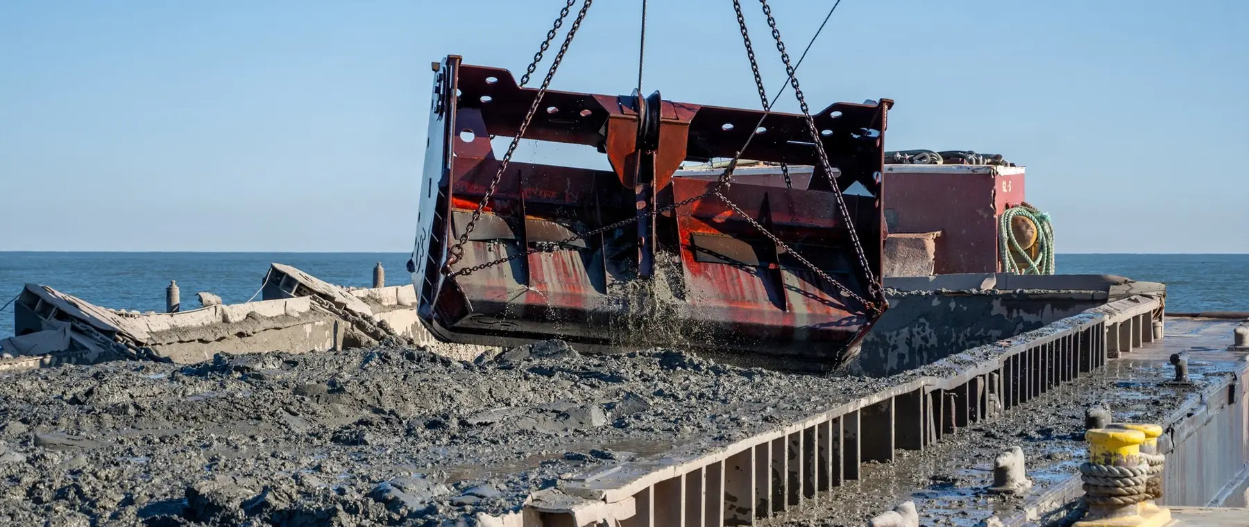
The documented milestone is the removal of approximately 109,000 cubic yards of sediment between 6 October and 5 November, following the contract awarded in July. The official photograph by Andre M. Hampton records the actual operation on 21 October. The two placement destinations distinguish this project from a simple account of material removed from a channel.
The wider implications for a yacht operator are the importance of understanding the responsibilities of harbour authorities, maintenance agencies and individual recreational facilities. A well-planned Lake Erie itinerary can make use of established navigation infrastructure while leaving the choice of destinations subject to the yacht's requirements and current conditions. The November announcement is a useful account of a completed public maintenance project, not a navigational clearance, a marina reservation or evidence of the future condition of the shoreline.
Sources and photograph
Source documentation: https://www.dvidshub.net/news/578722/sandusky-harbor-dredging-completed-benefits-local-beach-nourishment. Photograph: Sandusky Harbour dredging, 21 October 2026 — Andre Hampton / U.S. Army via DVIDS. Official public-domain U.S. Army photograph, credited to the named photographer; The appearance of U.S. Department of War (DoW) visual information does not imply or constitute DoW endorsement. See DVIDS copyright information.