An international gathering built on years of survey work
In a report published on 29 September 2026 and updated on 7 October, NOAA's Office of Coast Survey detailed the navigational preparation undertaken for this summer's Sail250 and International Naval Review. More than 60 tall ships and 40 naval vessels participated in the celebrations held between May and July in New Orleans, Norfolk, Baltimore, New York and Boston. The retrospective explains how several years of survey work, chart preparation and communication among authorities helped accommodate the visiting fleets. It is not an announcement of a new event or a newly opened yacht harbour. Its relevance to private yacht owners is the practical example it provides of how marine information can be assembled when a waterfront is required to support activities that differ substantially from its usual pattern. A yacht taking part in an organised gathering may have different dimensions from the featured vessels, but its skipper faces the related question of how to establish which information is reliable and appropriate for the intended movement.
Planning started well before the celebrations
For the Norfolk portion of the programme, planning began in 2023. The Mid-Atlantic Navigation Manager coordinated surveys covering parts of the waterfront and the Elizabeth River, while teams aboard NOAA Ship Ferdinand R. Hassler collected seabed information to help establish clearance for the deep-draft participating vessels. This chronology is particularly instructive because a chart update visible to a visitor may appear to be a relatively straightforward product. The collection, assessment, verification and distribution of the observations behind it required a longer programme. An owner preparing a yacht for an unusual voyage should similarly distinguish preparations that can be made shortly before departure from matters requiring extended investigation. Arranging a compatible berth, assessing the dimensions of the yacht and establishing the ability to operate in unfamiliar waters may need to begin months before guests arrive. The survey work undertaken for Sail250 was specifically commissioned for its participating locations; it does not establish that every nearby yacht facility received a corresponding survey.
Custom charting resources for New Orleans
NOAA reports that its Coast Survey personnel provided tailored charting resources for organisers in New Orleans. The Central Gulf Coast Navigation Manager and members of Navigation Response Team Gulfport also engaged with the public and local maritime professionals. The event illustrates the value of direct communication between the producers of geographical data and people who operate within the area represented by it. For a yacht captain, the distinction between an official navigational product and supplementary event information is important. An organiser's plan may identify where particular groups of vessels are expected to gather, while a chart represents navigational features within a defined area. A temporary restriction can change how the skipper is permitted to use a location without changing the underlying seabed or shoreline. Keeping these separate sources in context is more useful than attempting to combine their contents informally on a single screen without understanding their authority or date.
Baltimore and a rapid response to a missing buoy
The Baltimore preparations included survey work around anchorages and berthing areas. Navigation Response Team Patuxent conducted surveys, after which the Pacific Hydrographic Branch expedited verification. A notable incident occurred two days before the event when the Coast Guard requested assistance locating a missing buoy near the Chesapeake Bay entrance to the Chesapeake and Delaware Canal. NOAA's team deployed the following morning and located the buoy. The agency reports that this intervention helped prevent three participating vessels from being unable to reach Baltimore. The case is a useful demonstration of why an apparently familiar route can require additional investigation when actual conditions differ from the information available to navigators. A private yacht's lower draft may make some routes more accessible, but does not eliminate the need to establish the meaning of an absent or displaced navigational mark. The appropriate response is to obtain authoritative guidance rather than assume a missing mark was deliberately removed.
Bathymetric surfaces as additional information
The Baltimore preparations also involved creating high-resolution bathymetric datasets used by Maryland Pilots alongside electronic navigational charts. NOAA identifies these as S-102 products. Bathymetric information describes the shape and depths of the seabed across a defined area. The detail of a digital depth representation can help a suitably equipped and trained navigator examine a question about available clearance. It is essential, however, to consider such information in relation to the vessel's actual draft, chart datum, water level, the quality of the underlying survey and any other relevant factors. A product developed for professional pilots with a particular operational requirement is not automatically available or compatible with the chartplotter aboard a recreational yacht. An owner arranging new bridge equipment should obtain confirmation of the products the equipment supports and how they can be used. The report demonstrates a particular application during Sail250 rather than establishing a new mandatory electronics installation for private vessels.
Organising the exceptional traffic in New York
The New York preparations extended over a three-year period. Navigation Response Team New London conducted dedicated surveys at the request of the United States Navy, and NOAA reports that record ice coverage created difficulties during the final survey preparations. Its Northeast Navigation Manager established an online portal through which the Navy and Coast Guard could exchange geographic data. Cartographers incorporated temporary regulatory information covering 12 security zones, nine spectator zones, 34 naval anchorages and 23 berthing positions for tall ships. The scale of the exercise explains why ordinary cruising arrangements cannot simply be extended to a major gathering without investigating its temporary management. A private yacht might intend to watch a parade without joining it, but the position of spectator areas, prohibited waters and traffic arrangements can materially affect its options. An event chart or notice must be checked for its period of validity. Restrictions applicable to the July celebrations should not be assumed to remain in force in November.
Boston and the importance of using suitable data
In Boston, NOAA used recent harbour surveys to produce detailed depth information for local pilots dealing with vessels operating within tight under-keel clearance margins. The agency also describes educational activities undertaken for people visiting the celebrations. The combination is notable: public understanding of maritime navigation can be advanced alongside professional work without suggesting that both audiences require identical tools. The skipper of a privately operated sailing yacht may need to investigate a relatively deep keel when approaching an unfamiliar berth; a motor yacht of similar length may require a different assessment because of beam, height or manoeuvrability. Neither vessel can determine its route simply by examining the tracks of the tall ships that attended the event. For an intended voyage, the relevant current data should be selected according to the real characteristics of the yacht and the actual locations it will use. Historical examples are useful learning material, not instructions to follow a past event's route.
A practical example for owners planning marine events
Families hosting guests during a sailing regatta, boat show or waterfront festival can benefit from retaining flexibility in the arrangements. A booking for a shoreside function should not force the yacht to move when the captain identifies unsuitable conditions or restrictions. A confirmed berth in a less congested location, with an independently arranged transfer, may be a more comfortable choice for the group than trying to secure the closest possible position. The Sail250 retrospective illustrates the coordination needed even by experienced organisations with access to substantial survey resources. Owners planning smaller occasions should establish who is responsible for the relevant facility, which notices apply to the particular dates and whether the boat is suitable for the proposed arrangements. The captain's navigational decision remains separate from the organiser's desired guest itinerary. Understanding this division of responsibilities can make a private event more enjoyable without exposing the vessel to unnecessary uncertainty.
The enduring result of the summer programme
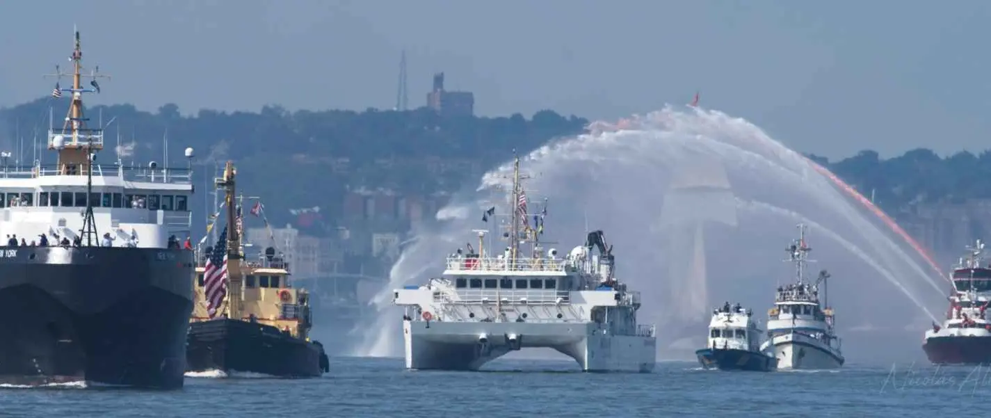
NOAA's report provides a documented account of cooperation among chart producers, survey teams, harbour stakeholders and the authorities managing an exceptional movement of historic and naval vessels. It also presents an example of the use of detailed digital bathymetric products alongside existing navigational information. The official photograph by Nic Alvarado shows NOAA Ship Ferdinand R. Hassler participating in the New York parade of sail. It records the summer event rather than current conditions. The lasting lesson for luxury yacht operators is to recognise how much work lies behind navigation information and to use the products appropriate to their own vessels and circumstances. The autumn retrospective can inform future preparations without being treated as a substitute for current charts, notices, harbour information or professional judgement.
Sources and photograph
Source documentation: https://nauticalcharts.noaa.gov/updates/clear-waters-safe-passage-how-noaa-supported-sail250-and-the-international-naval-review-americas-maritime-celebration/. Photograph: NOAA Ship Ferdinand R. Hassler at the New York Sail250 parade — Nic Alvarado / NOAA Office of Coast Survey. NOAA public-domain archival photograph, credited to Nic Alvarado / NOAA; no NOAA endorsement is implied.