The people behind the information on the bridge
On 2 November 2026, NOAA's Office of Coast Survey published an interview with Colleen Roche, its Northeast Navigation Manager. Rather than announcing a new navigation requirement or the release of a particular chart, the feature offers a useful account of how the agency connects the people who produce nautical information with those who depend upon it. For owners and captains of twelve-to-twenty-four-metre yachts, that relationship matters. A boat equipped with sophisticated electronics still depends on good survey information, reliable updates and officers who understand the limits of the information displayed. Roche's account is especially relevant to crews cruising the northeastern United States, where busy commercial approaches, tidal waterways and changing weather can demand careful preparation. The interview also places everyday navigation support in the context of NOAA's longer transition towards new hydrographic data products.
A career spanning measuring instruments and nautical information
Roche has served as Northeast Navigation Manager since 2018, according to NOAA's interview. She joined the agency in 2011, initially working with the Center for Operational Oceanographic Products and Services. Her previous responsibilities included leadership of engineering, development, application and analysis teams. The agency describes work involving the rebuilding and strengthening of water-level stations following Hurricane Sandy, changes from acoustic to microwave radar water-level measurement, development of an inundation dashboard and surveys of currents supporting oceanographic modelling. Those experiences illustrate the different kinds of observations that eventually inform practical decisions afloat. Before joining NOAA, Roche worked in private-sector engineering involving ports and coastal infrastructure. That background is pertinent to navigation management because the same waterfront can be understood differently by a designer, a surveyor, a harbour authority, a commercial master and the skipper of a private yacht.
Why a navigation manager matters to a yacht operator
In the interview, Roche explains that the work varies from day to day according to the issues raised by users. She also describes helping people find suitable NOAA tools and information. That is a reminder that a question about marine navigation is not necessarily answered simply by buying a new chartplotter or downloading another application. A skipper may need to establish which source describes a particular channel, what information is available about a survey, where to find observations of water level or currents, or how to investigate an apparent discrepancy in chart information. A navigation manager can help users understand the relevant agency resources. This should not be confused with an emergency response service, a guarantee of safe passage or a substitute for local harbour directions. An owner or captain remains responsible for arranging current information and exercising appropriate judgement before committing the vessel to a route.
Practical lessons from the water-level network
Water-level information is particularly valuable where a yacht's loaded draft leaves limited room beneath the keel. A nominal depth shown on a chart does not describe the depth beneath the boat at every moment of the day. Chart datum, observed water level, meteorological conditions, vessel movement and the actual seabed all require consideration. Roche's earlier work on water-level stations helps illustrate the measurement infrastructure behind that problem. An operator should understand the difference between a predicted tidal height and an observation from a station, including whether the station represents conditions at the proposed location. A measurement taken elsewhere cannot automatically be applied to an unfamiliar berth. Crews should also understand whether the draft figures they use include changes arising from load, trim and appendages. A comfortable clearance calculated from unsuitable assumptions is not a meaningful safety margin, regardless of the precision with which a screen presents the result.
Electronic charts and the information they represent
NOAA's account references its work towards next-generation nautical information and the transition involving the National Bathymetric Source and the S-100 framework. These topics should be distinguished. Bathymetry describes the depths and form of the underwater terrain; the National Bathymetric Source brings depth information together for further applications. An electronic navigational chart, meanwhile, is a structured navigation product. The way it appears to the navigator depends in part on the equipment and software interpreting the data. S-100 is a broader internationally developed framework for marine information products, not a single compulsory application that every recreational yacht must install immediately. The November interview discusses ongoing work, not a sudden new rule for recreational equipment. Owners contemplating an electronics refit should ask the installer which official chart products the proposed system supports, how they are updated and what the manufacturer has stated about future compatibility.
Maintaining an effective chart-management routine
On many luxury yachts, guests see the navigation system only when they glance at a display showing the vessel's position. Behind that simple view should be a routine for obtaining and assessing nautical information. The captain can identify the chart coverage needed for an intended cruising area, establish how the supplier distributes corrections or replacement data, and confirm that the installed equipment is displaying the appropriate edition. Changes to a planned trip may require additional coverage. A crew should know how to identify the source of the data shown on its particular system and distinguish a current official product from another layer of supplementary information. Before a passage, verify the appropriate published notices and operating information as well as the chart. An overnight download alone does not establish that every necessary item has been reviewed. For a professionally operated yacht, documenting these preparations makes it easier for another qualified member of the crew to understand what has been checked.
Where electronics can give misleading confidence
A brightly drawn chart with an accurately positioned vessel symbol can create an impression that the underlying depths are known everywhere to the same standard. In practice, age, coverage and quality of source information can vary. Users need to interpret the metadata and reliability information provided with the relevant chart product. A large yacht compared with nearby pleasure craft may draw significantly more water, have different turning characteristics or need greater clearance from fixed structures. Following another boat through a narrow approach does not demonstrate that the same route is suitable for the yacht. An apparently detailed image on a high-resolution screen should not be mistaken for a comprehensive contemporary survey. Sensible navigation preparation therefore includes identifying places where additional confirmation is required, consulting appropriate local information and allowing alternatives in the itinerary. The existence of newer marine data standards does not eliminate the need to assess individual conditions.
Making better use of the Northeast's coastal information
The value of navigation support is especially apparent when an itinerary changes unexpectedly. A visiting yacht may need to reconsider a destination after a weather forecast changes, identify a suitable alternative to an unavailable berth or plan an approach at a different state of tide. The captain should know the relevant harbour operator and appropriate official navigation-information channels before these questions arise. NOAA's account of Roche's work is an introduction to the human expertise behind these resources. Her own connection with recreational boating, including familiarity with chart 12304 earlier in life, also highlights that recreational navigators are part of the wider user community served by the agency. The interview is not a list of newly surveyed locations or corrected hazards, so it should not be used to infer that any particular northeastern channel is newly accessible. Instead, it encourages operators to develop familiarity with the sources that can help them investigate such questions properly.
An ownership consideration when upgrading the yacht
Owners often assess a navigation electronics proposal according to screen size, the appearance of the helm and advertised integration with other onboard equipment. Equally important are the quality and availability of the chart service, the support offered for updates, the crew's familiarity with the equipment and suitable arrangements when equipment fails. Before accepting a proposal, establish which chart provider is involved, what happens to subscriptions or access rights when the yacht changes hands, and how the crew would obtain the information required for a voyage if a display or network component became unavailable. A captain who has contributed to the upgrade specification can help ensure that the system meets the vessel's operational needs rather than merely providing attractive functionality during a demonstration. NOAA's description of the evolving marine-information environment strengthens the case for asking clear questions about compatibility and product support.
The implications of NOAA's November feature
The interview is ultimately a profile of a navigation manager whose experience connects engineering measurement, nautical information and the people using that information. For Luxury Yacht Guide readers, its relevance is practical: navigation is an ongoing process of understanding the vessel, its intended waters and the available evidence. Data standards and measurement techniques continue to develop, but the responsibility for a safe voyage remains with the people operating the yacht. The appropriate response to a question about an unfamiliar approach is to seek reliable, current information and reconsider the passage if important uncertainties cannot be resolved. NOAA's feature does not promise individual route approval or guarantee the accuracy of every display. It does, however, provide a timely opportunity for yacht owners to consider whether their own navigation processes make effective use of the authoritative coastal resources available to them.
Sources and photograph
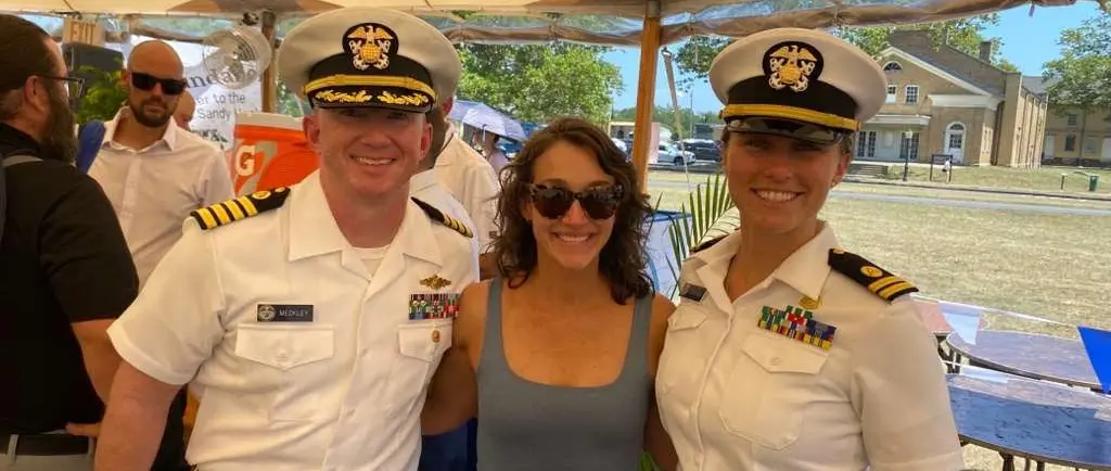
Source documentation: https://nauticalcharts.noaa.gov/updates/coast-survey-spotlight-meet-colleen-roche-northeast-navigation-manager/. Photograph: Colleen Roche meeting NOAA Corps officers — NOAA / Office of Coast Survey. NOAA public-domain photograph, credited to the Office of Coast Survey; no NOAA endorsement is implied.