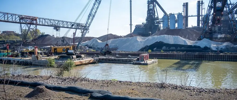
A November milestone on Lake Erie
The Buffalo District of the United States Army Corps of Engineers announced on 12 November 2026 that its autumn dredging programme at Cleveland Harbour had concluded the previous day. The works form the final part of an annual US$11.7 million contract awarded to DMYLES, Inc., and involved the removal of approximately 60,000 cubic yards of accumulated material from the federal channel in the upper Cuyahoga River. The Corps reports that the operation took 17 days, finishing 43 percent sooner than the planned duration. For owners and captains of larger recreational yachts on the Great Lakes, the development is relevant to understanding the continuing maintenance of shared navigation infrastructure. The completion notice concerns a specified federal channel project. It does not establish a new guaranteed depth throughout every recreational marina, private berth or approach on the Cleveland waterfront.
The importance of maintaining an established channel
Dredging in a working harbour is a fundamentally different undertaking from the development of a new marina. Its purpose in this case is to maintain the navigational function of existing infrastructure by addressing the accumulation of material in areas used by vessels. Ships and yachts with different dimensions can use parts of the same navigation system, even when their eventual destinations are quite different. A private yacht may enter a harbour whose maintained channel was designed principally around commercial traffic, then leave that channel to approach a recreational berth. The conditions and responsibilities relevant to those two parts of the journey must be considered separately. Completion of a federal dredging contract can therefore be useful context for a skipper's planning, but should not be interpreted as a blanket assurance about the condition of other waterways in the surrounding area. The correct question remains whether the actual route to the intended destination is suitable for the particular yacht.
Why shoaling can matter even to recreational vessels
A yacht may draw substantially less water than the large cargo vessels for which a commercial channel is maintained, but that difference alone is not a sufficient basis for assessing an approach. Some recreational yachts have relatively deep fixed keels, substantial displacement when loaded, or appendages that extend below their nominal hull draft. When leaving the principal channel, they may encounter considerably different constraints from those associated with the commercial route. Local accumulations of sediment can also alter the shape of usable water near the edge of a channel or in a turning area. The importance of an accurate survey is that it describes the configuration of the underwater terrain within its particular coverage, rather than only giving a single nominal depth. Captains should establish which information is current and relevant to the route, and avoid drawing conclusions about a side channel from maintenance activity reported elsewhere.
Reading authorised dimensions correctly
The Corps identifies authorised depths between 18 and 29 feet within Cleveland Harbour, with the upper figure associated with its entrance channel. Those figures describe the dimensions the federal maintenance programme is intended to support in different locations. They should not be confused with live measurements of water depth at every position within the harbour. The actual available depth can depend on lake level, the date and coverage of the survey used, local sediment movement and the precise location of the vessel. A captain must establish the applicable chart datum and use suitable current information about water levels. In addition, the boat's draft must reflect its actual configuration and loading. A published authorised channel depth may be helpful when examining a chart or discussing a passage with a local professional, but cannot replace a proper assessment of clearance. The November press release is evidence of completion of the autumn maintenance programme, not a current chart correction or a set of detailed hydrographic survey results.
Sharing an approach with commercial traffic
The Cleveland project is supported primarily by the need to maintain a working Great Lakes port. That is an important contextual fact for yacht operators. A large commercial vessel may have comparatively limited options for changing course or stopping within a narrow channel, whereas a recreational yacht may have more flexibility if it has been planned for in advance. However, the smaller yacht's actual manoeuvring characteristics depend on its machinery, helm arrangement, windage and the prevailing conditions. Captains should be familiar with the applicable navigational rules and local requirements, maintain a proper lookout and establish reliable communications as appropriate. The completion of dredging does not remove these responsibilities. When discussing a recreational visit with a marina or harbour contact, ask which arrival arrangements are appropriate for the particular vessel rather than assuming that a route shown on a general visitor map is intended for unrestricted recreational access.
The connection between dredging and the destination of sediment
Removal from a navigation channel is only one part of the operation. The Corps reports that the wider 2026 Cleveland programme included beneficial use of part of the recovered material through the port's processing facility, while the remainder was placed in a confined disposal facility. This illustrates why the logistical requirements of maintenance extend beyond the vessel or equipment performing the dredging. The characteristics of the material, the available handling arrangements and the suitability of the intended destination all affect how such work can be undertaken. The announcement does not establish that every load of material is suitable for unrestricted reuse. The beneficial-use component should be understood within the arrangements established for this specific programme. For yacht owners interested in the environmental management of the waterways they visit, it provides an example of how navigation maintenance can be linked to the management of recovered sediment rather than considered an isolated removal operation.
Interpreting the reported early completion
The Corps attributes a substantially shorter-than-planned duration to the autumn operation, comparing the completed work with other efficient dredging projects undertaken in the regional programme. This is useful information about the reported delivery of a defined contract, but it does not establish a corresponding reduction in all costs or the need for future maintenance. Dredging frequency on Lake Erie is influenced by changes in the channel and the priorities and resources available for subsequent work. A project completed ahead of its anticipated schedule still requires future monitoring of the infrastructure it was intended to maintain. A yacht owner planning a voyage next summer should not rely solely on an announcement published before winter. Appropriate current charts, survey information, notices and harbour instructions should be consulted at the time of the intended visit. The value of the completion report is to identify a documented maintenance milestone and provide a basis for asking more specific questions when arranging future movements.
Preparing a substantial yacht for Great Lakes cruising
For a yacht measuring between twelve and twenty-four metres, navigation infrastructure is one consideration within a wider ownership and cruising plan. An itinerary may involve sheltered recreational harbours, busy approaches, changing weather, restrictions associated with fixed structures and services designed for boats of very different dimensions. A yacht's actual beam, loaded draft, overall height and length should be documented accurately and supplied to relevant facility operators when making enquiries. The crew should also establish the availability of appropriate shore power, fuel, waste arrangements and safe access for guests. None of these services can be inferred from the dimensions of the federal commercial channel. Where an intended marina cannot meet the yacht's requirements, an alternative destination may be preferable to improvising an arrangement after arrival. The owner's programme will be more resilient if land-based arrangements and guest commitments can be adjusted independently of a particular berth or departure time.
What the November announcement establishes
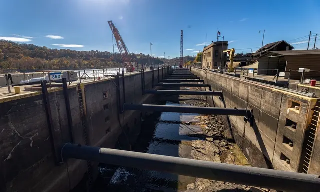
The Corps' statement provides a confirmed date for completion of Cleveland's fall dredging, identifies the approximate quantity of material removed and places the work within the annual maintenance contract. The official accompanying photograph, taken by Andre M. Hampton on 28 October, records the actual autumn works. It is not an image of a yacht marina or a representation of present navigational conditions. The announcement is of interest to private yacht operators because a shared harbour depends on continuing maintenance that is not necessarily visible to the visiting crew. Understanding who is responsible for the infrastructure, which areas have been maintained and what information is available about their condition can support a more informed approach to planning. The next step for a captain considering a visit remains obtaining the current information appropriate to the intended voyage and confirming the specific recreational arrangements directly with the responsible operators.
Sources and photograph
Source documentation: https://www.dvidshub.net/news/579219/cleveland-harbor-fall-dredging-completed-just-over-two-weeks-completes-117m-annual-operation. Photograph: Cleveland Harbour fall dredging, 28 October 2026 — Andre M. Hampton / U.S. Army / DVIDS. Official public-domain U.S. Army photograph, credited to Andre M. Hampton; The appearance of U.S. Department of War (DoW) visual information does not imply or constitute DoW endorsement. See DVIDS copyright information.