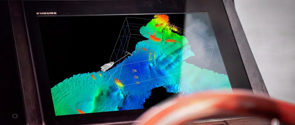
WASSP has introduced a forward-looking multibeam sonar that combines live underwater imaging with the ability to build a stored map of the seabed. The New Zealand marine electronics manufacturer presented FinFLS at METSTRADE, held from 17 to 19 November 2026 at RAI Amsterdam, where the equipment made its public debut at stand 08.630. For the luxury yacht sector, the announcement is particularly relevant to owners and captains considering navigation electronics for cruising grounds where detailed local depth information is limited.
The new equipment is built around a compact fin-shaped transducer with an integrated processor, rather than an arrangement requiring a separate external processing unit for the sonar. WASSP describes the system as a forward-looking volumetric multibeam instrument. Its published figures distinguish between detection of targets ahead and the shorter distance over which the seabed can be mapped. That distinction matters when assessing what a practical installation aboard a cruising yacht might deliver.
Looking beyond the conventional depth sounder
A conventional downward-looking depth sounder gives the crew information about the water beneath its transducer. FinFLS is designed to extend that picture into the volume of water ahead of the vessel. Its acoustic coverage can represent seabed contours and targets within the water column, giving the operator additional information before reaching a feature. The manufacturer also describes motion compensation and the ability to retain the data gathered over successive passes.
For a yacht approaching an anchorage, the distinction between sounding the depth at one position and examining terrain further ahead is significant. An electronic navigational chart remains the starting point for planning, but its survey dates, resolution and coverage may vary considerably. A live forward-looking sonar display can supplement that information where the crew wishes to understand changes in underwater terrain.
This does not amount to a guarantee that all underwater dangers will be detected. Acoustic returns depend on the geometry of the installation, depth, target characteristics and conditions prevailing at the time. The skipper must continue to use appropriate navigational procedures, available charts, local knowledge and a prudent approach speed. In particular, an apparently clear sonar display should not be interpreted as proof that a channel or anchorage is safe.
Understanding the published range figures
WASSP lists a maximum forward detection range of 400 metres and a maximum forward seabed mapping distance of 200 metres. Its technical information also specifies a maximum depth detection of 125 metres, a horizontal coverage angle of 70 degrees and a vertical coverage angle of 60 degrees. The manufacturer quotes mapping coverage of up to eight times water depth, subject to the published distance limits.
These are separate specifications rather than a promise of simultaneous maximum performance in every operating condition. A shallow approach, for example, should not automatically be assumed to provide a fully mapped corridor extending 400 metres beyond the bow. The range quoted for detecting targets is not the same as the maximum mapped distance for seabed contours.
The system uses chirp transmissions in the 135 to 155 kilohertz frequency range. WASSP specifies an operational mapping speed of up to 20 knots and says the fin is constructed to withstand speeds up to 40 knots. Again, the structural speed figure is not an assertion that mapping performance is available at that higher speed.
For yacht buyers, clear interpretation of these specifications is preferable to relying on headline numbers. The appropriate performance requirement depends on the intended cruising area, hull configuration and operating profile. A displacement cruising yacht and a faster planing motor yacht may need different installation assessments even if their overall lengths are similar.
A transducer with onboard processing
An important engineering feature of the launch is the processor integrated into the transducer assembly. WASSP says the compact composite fin contains the processing hardware required for the new system. The company publishes an average power consumption of 60 watts for the equipment and supplies a fairing block as part of its stated installation arrangement.
That design may be attractive to owners who want to minimise the number of separate electronic units installed in a machinery or technical space. The benefit, however, needs to be considered alongside the practical implications of installing a hull-mounted acoustic device. The transducer must be positioned where it can obtain a useful underwater view without unacceptable interference from the hull, appendages or water flow.
A competent yard and the manufacturer's distributor should examine the intended location before a purchase decision is made. The assessment should include available space, cable routing, structural requirements, hull material and compatibility with the yacht's existing electronics. The presence of a fairing block does not mean the same installation method will suit every hull.
For an existing yacht, this makes the project a possible item for consideration during a scheduled refit or haul-out. For a new build, the naval architect and electronics integrator can consider the transducer location at an earlier stage, when changes may be easier to accommodate. WASSP does not state that all vessels between 12 and 24 metres are suitable for the product; that conclusion must be reached individually.
Integration with Furuno displays
WASSP has announced native integration with Furuno's NavNet TZtouchXL platform. The system can also operate with the manufacturer's CDX-FLS interface on a computer, and the product information describes a software development kit option for third-party integration. The available software licences and functions need to be checked against the configuration being proposed.
Existing yacht owners who have invested in a compatible Furuno installation may therefore have a different upgrade pathway from those whose helm is built around another electronics ecosystem. Native integration is important because the space available for displays aboard a mid-sized yacht is not unlimited. A sonar picture that can be presented within a familiar interface may simplify the operator's working environment.
The manufacturer describes two-dimensional chart overlays, three-dimensional mapping and cross-sectional views. Its published material also identifies navigation telemetry including heading, position, pitch, roll, heave and depth, together with configurable warning and critical-depth overlays.
These presentation options need to be considered as part of the complete helm arrangement. A visually detailed three-dimensional image is useful only when the person interpreting it understands the display's orientation, scale, limitations and relationship to the vessel's movement. Crew familiarisation and an appropriate commissioning programme should be included in the installation plan rather than treating the equipment as a purely hardware upgrade.
Building knowledge of familiar cruising waters
FinFLS is designed to retain bathymetric information as the vessel travels. The resulting record may help a crew compare observations on subsequent visits to familiar waters. An owner who repeatedly cruises a region with intricate approaches could find this capability useful as an additional source of local knowledge.
Stored observations are not, however, an official hydrographic survey simply because the system has collected them electronically. Positioning quality, the accuracy of the installation, water-level changes, vessel motion and the way the observations are processed all matter when interpreting recorded depths. A previously recorded observation may also no longer reflect the current situation if the seabed has changed or a new obstruction has appeared.
The distinction between live information and stored mapping should consequently be clear to the operator. Yacht crews should retain appropriate charts and other established navigation resources. The new mapping capability is best considered a supplementary tool whose value depends on how it is operated and interpreted.
What the launch means for luxury yacht owners
The FinFLS announcement illustrates a wider development in marine electronics: technologies previously associated mainly with specialist surveying and commercial operations are being packaged in ways that may be applicable to a broader range of vessels. The specific attraction in this case is combining a live forward-looking image with persistent mapping, without requiring the crew to operate a dedicated survey vessel.
For a 12 to 23.99 metre motor yacht or sailing yacht, there are several matters to establish before proceeding. An owner should request the manufacturer's recommended installation arrangement, the complete equipment and software quotation, confirmation of display compatibility and guidance on the expected performance for the proposed vessel. The yard should then identify the installation work and commissioning requirements.
Owners considering an extended cruising programme may find that the value lies less in achieving the maximum headline range than in having a consistently interpretable view at the speeds and depths encountered during their actual passages. Equally, a yacht that spends most of its time in regularly surveyed channels and established marinas may place a different priority on additional sonar hardware.
Pricing, delivery timing and any vessel-specific installation costs have not been established in this report. The published specifications and the public unveiling at METSTRADE are the confirmed news. A detailed consultation with the manufacturer or its authorised distributor remains the appropriate next step for owners evaluating the equipment for an individual yacht.
In short, WASSP's launch broadens the choice of underwater information systems available for consideration by the luxury yacht industry. FinFLS combines forward-looking acoustic coverage, integrated processing and reusable mapping in one product platform. The engineering and navigational implications are worth examining carefully, with attention to realistic performance expectations and the continuing responsibilities of the skipper.
Sources and image
Primary sources: WASSP launch announcement and official FinFLS specifications. Lead image: WASSP official FinFLS launch illustration showing a Furuno display with three-dimensional sonar imagery. Supplied in the manufacturer’s media-facing launch announcement, credited to WASSP and resized for publication.