A charting update with practical consequences at the helm
NavimetriX has introduced support for C-MAP DISCOVER X and REVEAL X marine charts, adding a more detailed cartographic layer to an application already used for weather and route planning. The integration was described on 22 October 2026 by marine-electronics specialist Digital Yacht, while NavimetriX’s own documentation sets out chart licensing, supported devices and route-planning options. For cruising-yacht owners, the announcement is relevant precisely because it concerns the links between familiar electronic tasks.
A modern passage plan seldom comes from just one information source. The skipper may inspect forecast models, consult tidal predictions, review sailing performance and examine the approaches to an unfamiliar harbour on detailed nautical charts. Bringing those activities closer together can reduce the number of disconnected steps, although it does not eliminate the responsibility to verify any route independently.
The new chart options are not a claim that a tablet or laptop becomes a certified primary bridge installation. They are additional tools within a wider navigation workflow, and their value depends on sound chart coverage, correct vessel settings and disciplined cross-checking. That distinction is especially important for owners who move between a flybridge display, a lower helm and personal devices.
What DISCOVER X and REVEAL X add
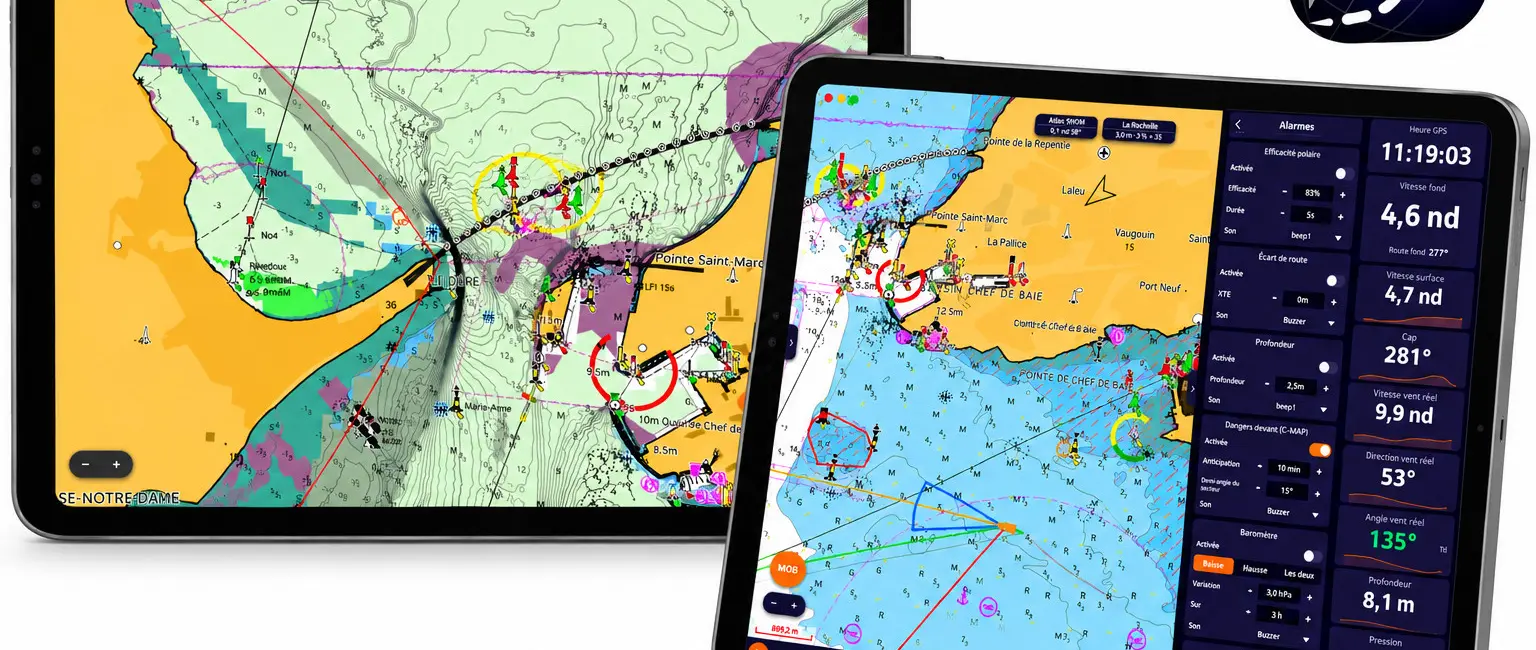
Digital Yacht says the integration brings C-MAP chart imagery, depth data and navigation detail into NavimetriX, including a choice of chart presentation modes and offline chart downloads. The result is a view of coastal routes that can be considered alongside weather forecasts within the same application. More detail on a screen is useful only when the navigator understands the source, update status and limits of each layer.
DISCOVER X provides the charting foundation, while the more detailed REVEAL X option adds visual information where suitable coverage is available. Digital Yacht identifies enhanced bathymetry, satellite context, seabed relief and information about bottom composition among the added layers. Those layers can help an owner think about the surrounding seabed and potential anchorage characteristics, but they are not a substitute for soundings or local advice.
NavimetriX’s own help pages confirm that some image layers, including satellite and relief presentations, are associated specifically with REVEAL X rather than the base chart package. The difference should guide a purchasing decision. A yacht cruising simple, well-known routes may not use every optional view, whereas an owner exploring unfamiliar coastal waters may find additional context worthwhile.
Route planning now takes account of charted constraints
One headline element is an AutoRouting capability that can use C-MAP information to prepare a route between an origin and destination. The manufacturer describes factors including charted depth, shoreline, underwater hazards and navigation restrictions, and its FAQ provides more detail about adjustable clearance and danger-distance settings. This can make the first stage of planning more structured than drawing every leg entirely by hand.
The route planner uses the vessel’s draft information, and its interface includes an under-keel-clearance margin. The official NavimetriX documentation describes separate options for avoiding shallow water and restricted zones, as well as limits around charted hazards. Each setting must be configured for the actual yacht and the intended operating conditions if its resulting track is to be useful.
Autogenerated lines deserve particular scrutiny at the entrance to marinas, in tidal waters and near temporary restrictions. Chart data can be incomplete, local notices may change and tidal estimates are not measurements of the water beneath a particular keel. A responsible passage plan still includes updated official publications where applicable, current weather, a look at traffic and the skipper’s own judgment.
A larger yacht benefits from small navigation decisions
On a yacht in the 12-to-24-metre luxury cruising range, arrival planning carries details that can be easy to overlook when discussing electronics in abstract terms. The route that looks broad enough on a small-scale chart may lead toward shallow patches, bridge restrictions or busy commercial traffic close to port. Draft, air draft and a vessel’s turning characteristics matter more than the convenience of a single-button plan.
A charter captain may use a planning application to communicate an itinerary to guests before the passage begins, while an owner-operator may prepare the same route at home. In both situations, the useful outcome is a clearer set of questions for the helm team: where is the safe water, what conditions would change the plan and what is the fallback approach? C-MAP integration can inform those questions without answering them automatically.
Additional chart layers are particularly tempting in picturesque anchorages where visual detail appears reassuring. Yet satellite images, colour relief and bottom-type interpretations are aids, not permissions to anchor. Skippers must still check local protected-area rules, the actual seabed, suitable depth, swing room and weather exposure before choosing a position.
Offline charts are about resilience, not immunity
NavimetriX allows selected chart areas to be downloaded for offline use, a practical feature when a yacht travels beyond reliable mobile coverage. A previously downloaded area can remain available when live connectivity is poor, which helps make a shore-side planning session useful on the next leg. This does not automatically mean every online service or updated weather feed will remain available without internet.
The platform’s FAQ adds an important detail about multi-device use: C-MAP chart data does not simply synchronise as a complete download from one tablet to another. Each supported device registers against the user’s C-MAP account and downloads its own areas. That distinction matters to a captain preparing a primary device and a backup before departure.
Owners should test the actual offline sequence while still connected, including opening the chart on the intended device and verifying the necessary coverage. It is equally sensible to confirm whether the applicable chart licence is active, whether current updates have been downloaded and how the app behaves after a device restarts. These simple checks prevent a feature advertised as convenient from becoming a surprise during a passage.
Device support, charts and subscriptions are separate decisions
NavimetriX documentation lists chart-capable versions for iPhone and iPad, Android, macOS, Windows and Linux, but explicitly excludes the browser-based version from displaying C-MAP charts. The distinction is easy to miss when a product works across many screens. Guests may be able to view planning information through a web interface without receiving identical chart functionality there.
The same documentation makes clear that charts are a separate purchase from the navigation app’s Premium subscription. C-MAP digital licences are bought through the relevant chart provider and then associated with supported devices; their specific terms govern use. It would be misleading to imply that every user receives detailed global charts just by updating the app.
Before committing to a particular onboard workflow, check the exact operating-system version, device performance, chart area and subscription terms. Compatibility with one operating system is not a promise that every ageing tablet or low-powered laptop will offer acceptable performance. The best time to resolve those questions is at the berth, not while approaching a crowded channel.
Connections to yacht instruments
Digital Yacht’s announcement also describes the possibility of combining the navigation application with information from compatible onboard equipment. Its NavLINK interface can send supported NMEA 2000 data over Wi-Fi, making instrument and position information available to certain devices and apps. Depending on the installation, that may include vessel position, instrument readings and AIS information.
This kind of integration should be planned by reference to the actual installed network rather than a generic compatibility claim. NMEA 2000 equipment, gateways, chart sources and mobile devices all need correctly configured interfaces. Owners should ask a qualified marine-electronics installer to confirm which data sentences and functions the complete installation supports.
A well-configured system can allow the helmsman to compare a chart route with live information in one familiar workspace. It does not remove the need for lookout, radar where fitted, reliable navigation instruments and the separate controls required for steering the yacht. Digital convenience is most valuable when it supports a robust and clearly understood bridge routine.
Weather routing stays part of the broader picture
NavimetriX was already a weather and route-planning platform before the C-MAP announcement. Its materials describe forecast-model comparisons, GRIB data, wind and wave information, currents and sailing-performance calculations. The new charts can therefore sit alongside route estimates shaped by the weather rather than replacing the application’s original purpose.
For sailors, that is significant because the shortest track over the seabed is not necessarily the best passage in a given breeze or sea state. A performance-based routing suggestion may need to be reconciled with coastal hazards, tide, crew comfort and the yacht’s cruising programme. Motoryacht users face different propulsion decisions but still benefit from understanding forecast uncertainty and alternative arrival times.
Those combined capabilities invite a useful planning habit: first define a safe passage area, then compare realistic options inside it. The charting layer can help identify obvious geographic constraints, while the weather information describes the likely conditions during the journey. A clear final passage plan should remain intelligible to every watchkeeper, not exist only as an automatically generated line on a personal device.
The owner’s checklist before relying on the update
The immediate next step for an owner or captain is to update the supported application and examine the chart terms for the intended cruising ground. Confirm which edition of C-MAP is appropriate, whether the digital licence works on all required devices and whether the chart areas are current. If REVEAL X layers matter to the programme, verify their actual coverage rather than assuming the same detail is available everywhere.
Then assess the vessel’s data. Draft, desired under-keel clearance and avoidance settings need to correspond to the yacht’s real operating constraints, while the route should be reviewed against official notices and local information. Where NavLINK or another gateway is involved, have the data connection checked before using its readouts operationally.
The wider lesson is not that navigation has suddenly become automatic. It is that a well-designed application can now bring more of a cruising yacht’s preparation into one place, making it easier to cross-reference the sea, the weather and the vessel. For a careful skipper, that is useful progress—provided the convenience of the interface never outruns the discipline of seamanship.
Primary sources and technical qualification
Product and integration details are drawn from Digital Yacht’s 22 October 2026 announcement and the NavimetriX official FAQ. The two sources independently explain the chart options and make it possible to distinguish announced benefits from device and licensing limits.
Feature availability, digital-licence conditions and chart coverage may differ across installations and will change with later software versions. Hero image is the official NavimetriX/C-MAP release image distributed by Digital Yacht; this report makes no claim that automatically generated routes replace professional passage planning.